
The Cape to Cape Track is a walking trail through the Leeuwin-Naturaliste National Park, in the far south west corner of Western Australia, three hours drive south of Perth. The walking trail symbolically has the Cape Leeuwin Lighthouse at the southern end and the Cape Naturaliste Lighthouse at the northern end. This walk can be done in either direction but Auswalk, the company which organised the walk, accommodates interstate and international visitors, and have found it best to take the northerly route, with then only a two hour journey at the conclusion to return to Perth.
In April, I had the pleasure of participating in a ‘Cape to Cape’ walking holiday. This is perhaps a lesser known and seldom thought of alternative to the typical fly/drive type of holiday, but thoroughly enjoyable.
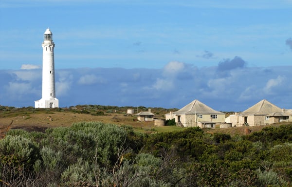
After a good night’s rest in Augusta and suitably clothed and shod, our driver delivers us at the starting point, the majestic Cape Leeuwin Lighthouse. This lighthouse was built in 1896 and stands 39 metre tall, and commands a breathtaking view of the meeting of the Southern and Indian Oceans. Being visible 47 kilometres out to sea, is a significant navigation point and a warning for the offshore reefs in this region. Lighthouses hold immense attraction to many people, being built in highly exposed locations, in an era and with materials that must have caused much hardship to the builders. We owe the present maritime safety to these builders. The weather on our visit was picture perfect, with a mere zephyr of a breeze, but it took little imagination to muse what the this exposed cape is often like.
Also in the lighthouse precinct is the Water Wheel. Though now inactive through calcification, this ingenious construction drove a hydraulic ram that pumped water to the lighthouse cottages from a low lying fresh water swamp, operating 24 hours per day.
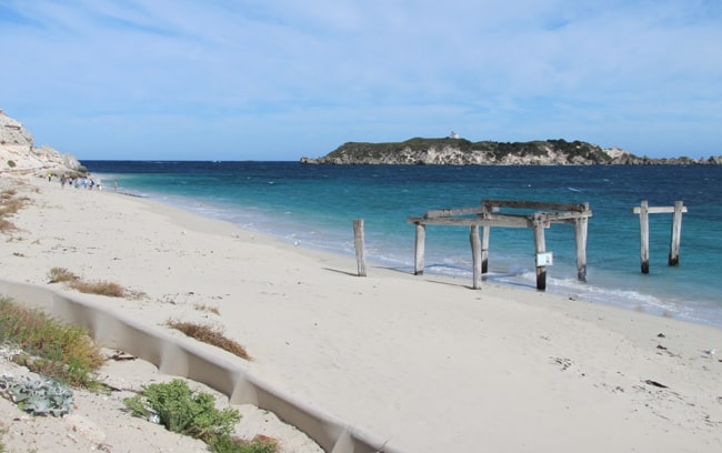
The Cape to Cape commences here and is well marked along the entire trail. The track takes in varying surfaces, from firm packed soil, to light vegetation, sandy tracks, and some beaches as well. The path takes us to Quarry Bay, Deepdene Beach and Hamelin Bay on a magnificent 24 degree windless blue sky day. The trail winds in and out from the coastal edge, taking in a succession of scenic bays, beaches and rocky inlets. The rock formations are interesting, being the eroded remains of a 600 million year old granite – limestone ridge. Hardy coastal shrubs brushing against the shins are a nice morning wake up call, and a polite reminder to wear gaiters next time! As were worn by the shrewd and more experienced in our team. But nothing could take away from the magnificent scenery, with the photographers amongst us in overdrive. Also here is the Walker Registration Booth, for us to sign in and register. A casual glance through the register reveals names and addresses from many interstate and international visitors.
Apart from the nine day Cape to Cape, Auswalk also offer a nine day Australia’s South West walk, taking in the magnificent forests from Pemberton to Albany in Western Australia, with overseas visitors often doing the two walks before leaving our shores. Auswalk arrange transfers, accommodation and most meals, with a high energy picnic lunch and snacks to nibble on through the day. A shady picturesque place to stop for a breather is seldom hard to find.
We soon get into a steady walking pace and the kilometres peel away like coins on a ‘trunk call to Kurdistan’. Our first day puts a lazy 21 kilometres behind us, but to be truthful it was of little effort.
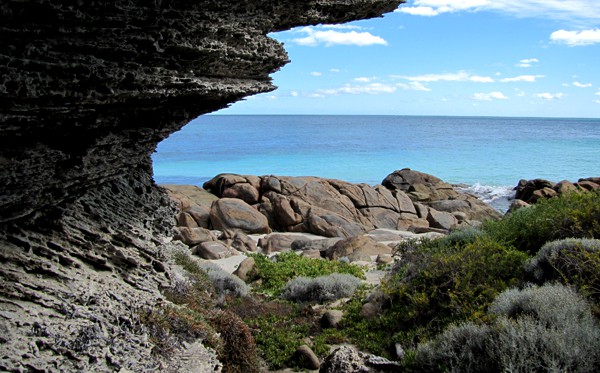
Our next leg was to the unassuming Fouls Bay Lighthouse, a small but practical construction, offering excellent views from Hamelin Bay to Fouls Bay and providing coastal navigation for the offshore islands and rocky hazards. Hamelin Island offshore is free of foxes and feral cats and is an excellent breeding ground for region’s bird life. The rock formations along this coastline have unusual ‘solution holes’, formed by the sand surrounding trees and solidifying, before the tree died and decomposed away.
The marked trail winds north, taking in light scrub land, eucalypts, grass trees and banksias, with every turn and hill offering yet more different and interesting scenery. Our trail takes in magnificent Karri forests, the occasional flowering acacias and pigface, native birds and now and then a scuttle off into the undergrowth.Although the provided documentation suggests, and offers advice on snakes, sightings are rare throughout the week. Catching a brown snake in mid-lunch provided a unique photo opportunity however.

Auswalk walks are well documented, providing excellent walking notes on points of interest along the way and, information on the flora and fauna you may encounter. Our trail then takes in a long walk up Boranup Beach, a good test of the legs. The sand is lightly packed and we are just thankful we did not also have a headwind. These southern beaches feature excellent fishing as the schools of salmon move through, being spotted from the headlands. We meet a few fishermen, mostly amateur anglers but also a couple of well organised teams of professionals, watching and waiting for the schools. One catch of herring being cleaned looked good and reminded me of an excellent Italian recipe I have at home for them.
At the end of a long day we walked into our accommodation at Margaret’s Beach, the accommodation chosen by Auswalk was a veritable oasis with excellent rooms and facilities. These rooms are equipped with washer and dryer, allowing us to get the laundry under control while enjoying a well earned cold one. Having a full kitchen, we treated ourselves to a bacon & eggs breakfast to start the day, knowing quite well we did not have to worry about the calories!
Our next section of the walk takes us through the Margaret River winery region, and a concerted effort places us in our accommodation early enough in the afternoon to sneak out and visit some wineries – no less than an obligation. With over 100 wineries to choose from, visitors are rarely disappointed. With wineries offering free freight and carton quantity discount to eastern states, they are hard to refuse. The wineries are beautifully presented with irrigated manicured gardens, offering excellent facilities for the arts, such as the soundshell amphitheatre at Leeuwin Estate Winery and the priceless art gallery at Vasse Felix Wines, to mention but a couple.
Our trail resumes on the beach with crossing the mouth of the Margaret River. Seasonal rains and tide dependent, this may be an uninterrupted sandy beach or a canoe crossing, with the former in our case. In fact, I was 50 metres along the beach before I realised we had passed what was supposed to be the mouth!
Our next accommodation chosen by Auswalk is a beautiful residence converted to guest accommodation. Managers, Elaine and Steven are excellent hosts and make us very welcome. The extensive grounds, fruit trees, birds and visiting kangaroos, create a haven at the end of a weary day. Our trail takes in the historic Ellensbrook House, a National Trust property. Built in 1850, this house was the hub of a beef and dairy cattle farm and pastoral lease occupying 30 kilometres of coast.
This entire coastline is a Mecca for surfers, with beaches and surfing areas having intriguing names like Grunters, The Womb, Lefthanders, and rather daunting names like Guillotine and Gallows. As the saying goes, you don’t have to be crazy, but it probably helps. We walked through only a couple of days after a major surfing competition at Margaret River beach and the infrastructure was still being dismantled. Our trail also visits the Gracetown Tragedy Memorial, where five adults and four children lost their life on 27 September 1996 after a cliff gave away while viewing a surfing carnival. This is a truly fitting monument.
Our trail now leaves the beach, and takes us into the hinterland again, through flowering honey scented melaleuca’s and stands of grass trees. Working our way in and back along the cliff tops, and to Wilyabrup Cliffs where the truly daring abseil and climb the sheer faces.
Walking Day 6 and our documentation informs us we are in for a 25 kilometre day. As if that is not enough, some of the trail is through some soft dunes, with a couple of sections considered ‘challenging’. Working our way up to Moses Rock lookout, the vistas continue to be breathtaking. Though not a surfer, the breaks close in off the beach are without doubt a magnetic attraction for the disciples of the surf. For myself, at least 40 times so far I wish I had fishing gear with me, because I swear you would have to hide your bait. The last five kilometres this day are a descent to, and a walk along Smiths Beach. An excellent swimming beach, we had come prepared and had a relaxing swim before walking into our accommodation at Yallingup. Marilyn and Col, our hosts from Auswalk, will be written into my will for the jug of Swan Draught awaiting our arrival. The medicinal qualities of the amber fluid are greatly underrated. Our accommodation is a heritage listed country retreat with art deco styling, and has an excellent collection of posters, photos and memorabilia in the bar/restaurant area.
Our last walking day is scheduled as a trifling 17 kilometres, which by now is basically like going to the shop for the paper. We are wondering what we are going to do after morning tea? This is the final day and our leg from Yallingup to Cape Naturaliste is no less spectacular. The track takes us mostly along the cliff top, offering splendid views north and south, turtles and schools of dolphin effortlessly riding the ocean swells. This section of beach is accessible by 4WD vehicles only, and the surfers that know this region want it to stay that way! The perfectly formed waves are a stones throw from the beach and we are entertained with the surfer’s skills for a while before moving on. This beach ends at Sugarloaf Rock, a pinnacle of rock just offshore. From Sugarloaf Rock our track winds inland and the first glimpses of Cape Naturaliste Lighthouse are seen. Gradually ascending to the lighthouse we arrive at the reciprocal Visitor Registration Booth, where we officially sign off from the walk.
Arriving at the Cape Naturaliste Lighthouse was tremendously rewarding, with the construction and precinct no less commanding and majestic. As this lighthouse is constructed on a 100 metres high bluff, it was only needed to be built 20 metres high to fulfil its task. The staff at the lighthouse are particularly amenable to the Cape to Cape walkers, and are only too pleased to take group photographs and tell about the lighthouse.
To our surprise, we met few walkers along the majority of the track, encountering a couple of school groups nearer to Cape Naturaliste. The track is well maintained and free of any litter.
We experimented with a downloadable iPhone application called ‘Runkeeper’, that links to Google Maps and GPS to track and record data of your walk. This tracked our walk from Yallingup to the lighthouse at 15.27 kilometres, and calculated calories burned from the altitude data. Though geeky, this is an excellent application, with the data also accessible from your home computer.
Our final leg is to our last accommodation, a couple of kilometres along one of the well marked Cape Naturaliste trails.
Our final accommodation, reception, guest rooms, restaurant, pool and spa, and of course, the bar, are all luxurious, but a long hot bath was the order of the day and did wonders for the muscles. After a leisurely breakfast, we gathered for farewells and to all make our way home, all sad it had come to an end.
To some, walking 135 kilometres in the week and calling it a holiday might seem a little daunting (or daft), but with some preparation in the preceding month of a few kilometres per day, you will not be troubled. Also important are good quality and well worn in walking shoes or boots. They may give you blisters when first wearing them, but your feet and those boots will come to a compromise! They will then be your best friends. Quality hiking clothing , as made by Kathmandu or Columbia, is highly recommended (30+ sun protection and rapid dryng), as are good socks, wide brimmed hat, 30+ sunscreen (sweat resistant), and a back pack you will not want to hurl into the first creek. I did not have gaiters but I would recommend them. Though I personally drink about as much water as a Kalahari Bushman, two to three litres per day is the recommended carry and consumption.
It was a pleasure to make new friends in Marilyn Col, Melanie, Judith and Phil, with plenty of opportunity to chat along the way as well as around the dinner table in the evenings. I guarantee you will come home leaner, fitter, tanned and ready to jump out of your skin, have taken taken plenty of photos and met new friends. And, you see so much on foot than in a car. What could be better?
ABOUT AUSWALK AND THE CAPE TO CAPE
Auswalk are based in Halls Gap in Victoria and have 19 walking destinations across Australia in their program. https://auswalk.com.au/
The Cape to Cape is a nine day excursion, with day one and day nine being travel days, walking for the other seven days. Distance walked is 135km.
Auswalk endeavour to book quality accommodations and may differ to those mentioned in this article, all dependent on availability. Auswalk walks are self guided, with supplied walking notes and maps, though a guide may accompany you if you prefer.
You only need carry a day pack for water, camera, day lunch pack (supplied) and waterproofing, your main luggage is moved ahead and waiting for you each day.
The Cape to Cape is available all year round, though the wildflowers in spring are heavily booked and would be exceptional – June/July are a statistically higher chance of rain.
The weather in April was perfect though the week before and after, were both in the 30s. Auswalk documentation links to weather predictions for you own choice.
Auswalk run a loyalty program that rewards repeat clients, such as the 11th booking free, as well as early payment discounts.
Story & Photography: Trevor Snow
Trevor is a real globetrotter who can't get enough of travelling. He loves soaking up new cultures and learning about different ways of life. His many trips and chats with people from all sorts of backgrounds have given him loads of cool knowledge that goes way beyond what you'd find on a map.
When he's not travelling, Trevor's probably got a camera in his hand. He's got an amazing eye for capturing those special moments, and his photos really show off his skills and experience. He's often wandering around cities, looking for that perfect shot that sums up the vibes of everyday life.
With his mix of interests and experiences, Trevor's got a really unique perspective on things. His travels and photography have made him a bit of an expert in his fields. Whether it's travel advice or a discussion about visual arts, Trevor's your go-to guy.
0 Comments